MeasureManageMitigate
URIMPACT is the leading ESG reporting and GHG emissions tracking platform for enterprises in Saudi Arabia and the Middle East. Measure Scope 1, 2 & 3 emissions, automate sustainability reporting, and accelerate Net Zero — powered by AI.
Trusted by Leading Institutions
Trusted by leading universities, government bodies, and research institutions across Saudi Arabia.


Why Sustainability Transformation Cannot Wait
Global regulations, investor pressure, and climate risks are forcing organizations to rethink operations. Yet most enterprises struggle with fragmented ESG data, manual reporting processes, and lack of visibility into carbon emissions.
URIMPACT helps organizations move from disconnected spreadsheets to intelligent sustainability management.
ESG Reporting Complexity
Multi-framework requirements create compliance bottlenecks and resource drain.
Scope 3 Data Gaps
Supply chain emissions remain invisible without integrated data collection.
No Decarbonization Visibility
Organizations lack clear roadmaps to track progress toward climate targets.
No Actionable Roadmap
Data without strategy leaves sustainability goals unachievable.
One Integrated Sustainability Platform
URIMPACT combines ESG management, GHG accounting, decarbonization intelligence, and Nature-Based Solutions into a single enterprise platform.
ESG Management
Track ESG KPIs across environmental, social, and governance pillars with automated workflows, compliance mapping, and performance dashboards.
ESG Management
End-to-End Sustainability Services
Satellite-Verified Tree Planting Certificates
Perfect for corporate social responsibility initiatives and sustainability commitments. Reports are structured to meet Verra VCS, Gold Standard, and other carbon credit certification requirements.
- Verification certificates
- Satellite imagery proof
- GPS-verified tree counts
- Shareable impact reports
- Biodiversity assessment
King Khalid University - Green University Project
Trees Detected
Via Satellite Imagery
CO₂ Sequestered
Verified Carbon Removal
Area Covered
Monitored Green Zones
From Measurement to Impact
Collect
Integrate sustainability data from operations, facilities, procurement, logistics, and suppliers.
Measure
Calculate ESG metrics and GHG emissions across Scope 1, 2, and 3.
Analyze
Identify carbon hotspots, risks, compliance gaps, and improvement opportunities.
Decarbonize
Implement reduction strategies and Nature-Based Solutions aligned with business goals.
Report
Generate investor-grade sustainability reports aligned with global frameworks.
Built for Global Sustainability Frameworks
URIMPACT simplifies sustainability disclosures by aligning your reporting workflows with globally accepted standards and regional compliance requirements.
Global Reporting Initiative
Sustainability Accounting
Climate Financial Disclosures
International Financial Reporting
Corporate Sustainability Reporting
Greenhouse Gas Protocol
Carbon Disclosure Project
Sustainable Development Goals
AI-Powered Sustainability Intelligence
Transform sustainability data into strategic decisions using predictive analytics, automated emissions calculations, and intelligent recommendations.
AI-Assisted Data Extraction
Automate data ingestion from multiple sources.
Automated Emission Mapping
Real-time mapping of emission sources across operations.
Risk Prediction
Identify climate and regulatory risks before they escalate.
Smart Benchmarking
Compare performance against industry peers and best practices.
Decarbonization Recommendations
AI-generated action plans to accelerate Net Zero goals.
Where Technology Meets Nature
Unlike traditional ESG software platforms in Saudi Arabia, URIMPACT combines digital sustainability intelligence with real-world Nature-Based Solutions to create measurable environmental impact.
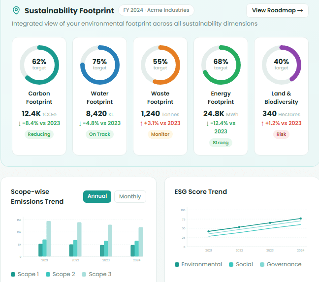
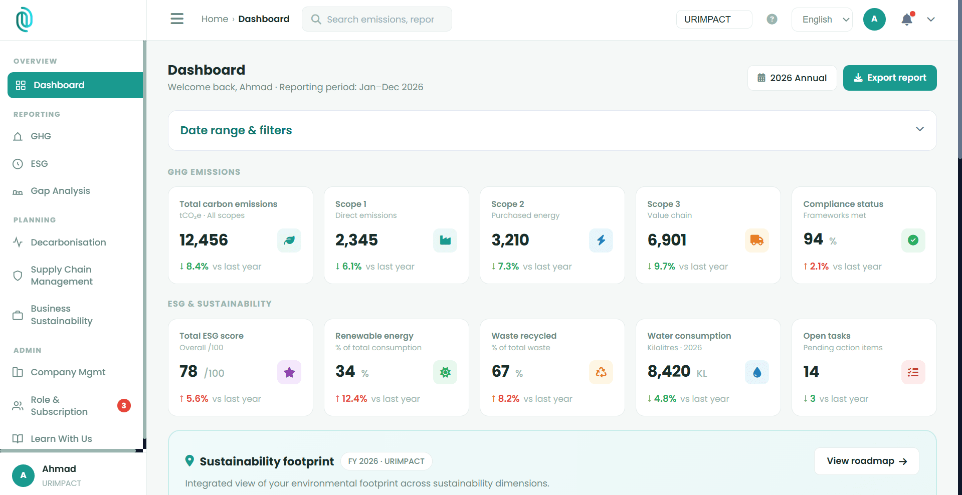
Visualize Sustainability in Real Time
Explore URIMPACT's dashboards — from carbon emissions and decarbonization roadmaps to gap analysis and supplier assessments.
Executive ESG & emissions dashboard
Traditional vs. Automated Monitoring
Traditional Tree Monitoring Is Costly & Inefficient
Manual Field Visits
Requires teams to physically visit sites, consuming time and resources
Delayed Reporting
Data collection and analysis takes weeks or months to complete
Limited Coverage
Difficult to monitor large or remote areas comprehensively
High Costs
Travel, personnel, and equipment expenses add up quickly
URIMPACT Provides Automated Satellite Monitoring
Automated satellite monitoring + AI-driven analysis provides continuous, verifiable, and auditable insights across every planting project.
Real-Time Data
Continuous satellite monitoring provides up-to-date insights daily
Full Coverage
Monitor any location globally, regardless of size or accessibility
Cost-Effective
Eliminate travel costs and reduce personnel requirements significantly
Transparent Reporting
Automated reports and dashboards keep all stakeholders informed
Sustainability That Creates Business Value
Real Sustainability Outcomes
Complex Scope 3 emissions across 200+ suppliers
Automated supply chain emission tracking with AI-powered insights
* These outcomes are based on pilot initiatives and use-case simulations
Webinars & Workshops
Sustainability doesn't have to be complicated
We deliver workshops and webinars that simplify compliance, making it practical, engaging, and easy for every team
About URIMPACT
URIMPACT is a sustainability intelligence platform helping organizations accelerate their transition toward responsible, resilient, and low-carbon operations. We combine ESG management, GHG accounting, carbon accounting, AI-powered decarbonization, and Nature-Based Solutions into one integrated ecosystem designed for modern enterprises.
To simplify sustainability transformation through intelligent technology and measurable environmental impact.
To become the leading sustainability operating system for enterprises across the Middle East and beyond.
Ready to Accelerate Your Net Zero Journey?
Designed for enterprises building climate resilience, ESG leadership, and long-term sustainability impact.